Beyond the Map: The Ecology Guiding Beachmere’s Foreshore Rules
While recent updates to Beachmere’s foreshore zones have focused on where dogs and horses can go, the changes are rooted in something less visible but deeply important: the survival of shorebirds that rely on this stretch of the Moreton Bay coastline.
Understanding how these birds use the foreshore helps explain why access has been reshaped — and what the rules mean in everyday practice for locals.
Beachmere’s Role in a Global Migration Network
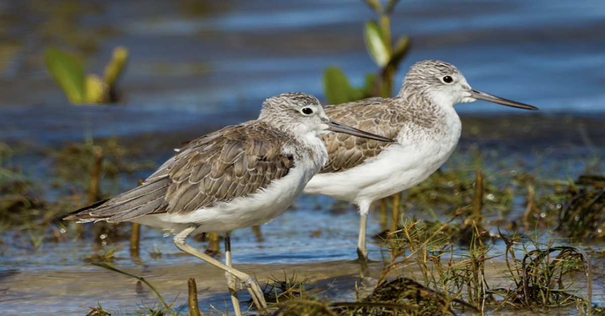
Beachmere sits within the wider Moreton Bay wetland system, recognised internationally for its importance to migratory shorebirds. Each year, birds such as eastern curlews, bar-tailed godwits and red-necked stints arrive here after travelling thousands of kilometres from breeding grounds in Siberia and Alaska.
For these birds, the foreshore isn’t just a resting place. It’s a vital refuelling stop where they must feed efficiently during low tide to build the energy needed for survival and future migration.
This is why the recent foreshore changes are not simply about managing recreation but about protecting a habitat operating on tight ecological margins.
Why Disturbance Matters More Than It Appears
Shorebirds are particularly sensitive to disturbance. When startled by fast-moving dogs, repeated foot traffic, or unexpected activity, the birds are forced to take flight, burning energy they can’t easily replace.
While a single interruption may seem minor, repeated disturbances can prevent birds from feeding during critical feeding windows. Over time, this can affect survival and breeding success.
This ecological reality underpins the foreshore map outlined in the companion article, which adjusts access to reduce repeated disruption rather than exclude people altogether.
Why Dogs and Horses Are Managed Separately
Dogs are one of the most significant disturbance pressures for shorebirds, even when they are well-trained. From a bird’s perspective, a running dog closely resembles a predator, triggering an instinctive flight response.
Horses, while generally less reactive, still create pressure through size, movement and trampling of soft sediment where birds feed.
The updated foreshore layout reflects these differences. By separating dog off-leash areas from key roosting and feeding zones, and directing horse riding to defined corridors, the aim is to allow recreation to continue while minimising repeated stress on wildlife.

Seasonal Rules That Follow the Birds
Some of the most common questions from locals concern seasonal access. These dates align with shorebird migration cycles rather than the calendar year.
Peak migration and feeding periods typically occur between late winter and early autumn, when birds are most dependent on undisturbed access to tidal flats. Seasonal on-leash requirements during these months help create predictable, lower-stress conditions, while still allowing greater flexibility outside peak periods.
This approach works alongside the mapped zones described in the foreshore update, adding a time-based layer of protection.
What the Rules Mean in Practice
On the sand, the changes are less about restriction and more about awareness:
- Dogs using off-leash areas away from bird feeding zones reduce repeated flushing.
- Leashes near roosting areas help birds remain settled during low tide.
- Horses staying within marked corridors avoid fragile sediment and feeding grounds.
- Temporary signage highlights areas that shift with tides and seasons.
Together, these small adjustments allow people and wildlife to share the foreshore more effectively.
A Foreshore That Works for People and Nature
Beachmere’s foreshore is unusual in that it serves both as a neighbourhood beach and an internationally significant habitat. The updated map provides the framework, but its success depends on how it’s used day-to-day.
When viewed alongside the foreshore map changes, the rules shift from enforcement to stewardship—a shared effort to keep this coastline functioning for the birds that depend on it and the community that enjoys it.

Featured Image Credit: Brian Russell/QLDGov