Newport Living: Close to Water and Closer to Community
Newport was once populated by cattle and crabs, but now the marina and surrounding residential development has become one of Queensland’s most engineered residential landscapes.
The low-lying grazing country was also well known for crab pots from local residents who would walk along the mud flats. The area was prone to seasonal inundation as well as from king tides, which meant that it was considered opportunistic grazing country, in that when conditions were good cattle would roam but it was abandonned when conditions were not good.
The boundary between the mangroves, the saltmarsh and the rough paddocks would change continually.
World-class engineering has established the area as a high-end residential neighbourhood, where house prices are starting to run alongside those in Santa Monica in California.
Residents of Newport know that water access isn’t reserved for the weekend. It’s built into the routes people naturally take past the lake, along foreshore paths, near canal edges, and that proximity changes how people use their time.
This is not in a dramatic, “every day is a holiday” way. It’s more in the quiet accumulation of small decisions: choosing a short walk instead of another scroll, letting kids burn energy at the park after school, or stepping outside for ten minutes because the view and breeze make it feel worth it.
Over time, those low-effort moments become routines, and routines are where a suburb’s social life starts to show itself.
The daily rhythm effect: mornings and dusk become “outside time”
When water is nearby — sometimes directly behind homes, sometimes via short walks to the lake and parks. People often find it easier to get outside in small, repeatable bursts, especially in the cooler edges of the day. That repeatability matters socially because the shared paths and shared timing can turn strangers into familiar faces. It’s also simply because you keep running into the same people doing the same loops.
It’s not guaranteed community, as no place can promise that, but Newport’s design tends to make “being out” a normal part of daily life, which increases the odds of casual connections.
Newport price signals near the water
The concentration of recent top sales along streets such as Aqua Street, Quay Circuit and Coolum Parade reflects how strongly location and orientation influence value in Newport.
Ben Hyrapietian recently completed the sale of 70 Coolum Parade, a 5 Bedroom/3 Bedroom home built in 2024, for an undisclosed sum believed to be the highest price in Newport of 2026. Roxanne Paterson recently sold 109 Aqua Street, a 5 Bedroom 3/bathroom house for $2,730,000 and Dianne Clarke handled the sale of a 4 bedroom/3 bedroom house, 37 Aqua Street which she sold for $2,680,000.
These transactions suggest buyers are weighing daily experience — views, breezes, walkability and access — alongside traditional metrics like size and finish, with water proximity acting as a multiplier rather than a bonus.
Recent results help illustrate how lifestyle and location combine to drive Newport’s premium market segment.
- 109 Aqua Street, Newport — $2,730,000, sold 11 Dec 2025
- 10 Palmer Court, Newport — $2,710,000, sold 18 Nov 2025
- 37 Aqua Street, Newport — $2,680,000, sold 01 Dec 2025
- 213 Coolum Parade, Newport — $2,350,000, sold 13 Nov 2025
- 72 Quay Circuit, Newport — $2,080,000, sold 22 Dec 2025
- 131 Aqua Street, Newport — $2,040,000, sold 18 Nov 2025
- 150 Ashmole Road, Newport — $1,985,000, sold 10 Nov 2025
- 14 Voyage Street, Newport — $1,825,000, sold 23 Dec 2025
- 2 Voyage Street, Newport — $1,640,000, sold 01 Dec 2025
- 401/11 Aqua Street, Newport — $1,575,000, sold 17 Dec 2025
For buyers weighing lifestyle alongside long-term value, Newport offers a clear example of how environment and liveability work together. Direct and near-water access continues to shape both daily routines and market demand, reinforcing the suburb’s reputation as a water-centred community. Understanding both the lifestyle advantages and the practical responsibilities allows buyers to make confident decisions, and helps ensure the qualities that make Newport distinctive continue to be preserved.
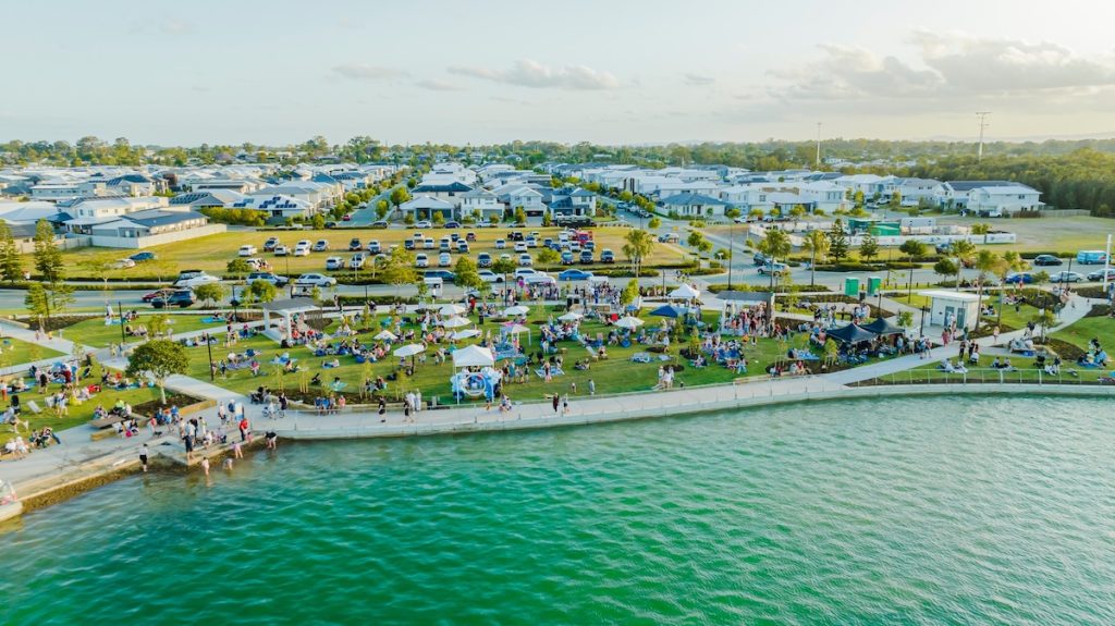
The lake effect: recreation becomes habitual, not occasional
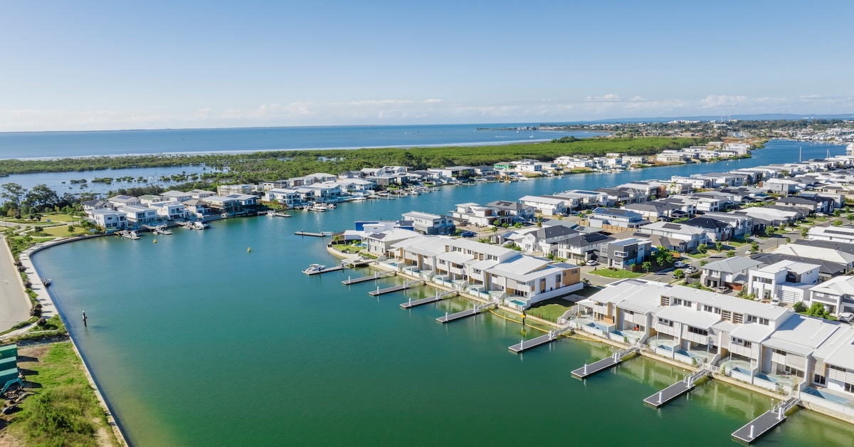
A key anchor of this lifestyle is the lake. Stockland describes Newport’s centrepiece as a 22-hectare lake and has publicly documented milestones in its construction and filling.
What that means on the ground is simple: you don’t need to plan a big outing to feel like you’ve “done something.” The lake edge supports easy repetition—walking, cycling, sitting, watching kids play—and those are the exact kinds of activities people sustain long term because they don’t require a schedule.

This aerial perspective helps explain why water becomes a default presence in daily life at Newport. The canal system isn’t a single feature but a connected network, layered around the marina, lake and residential streets, shaping movement patterns, sightlines and access across the suburb.
Spinnaker Park: access that feels shared
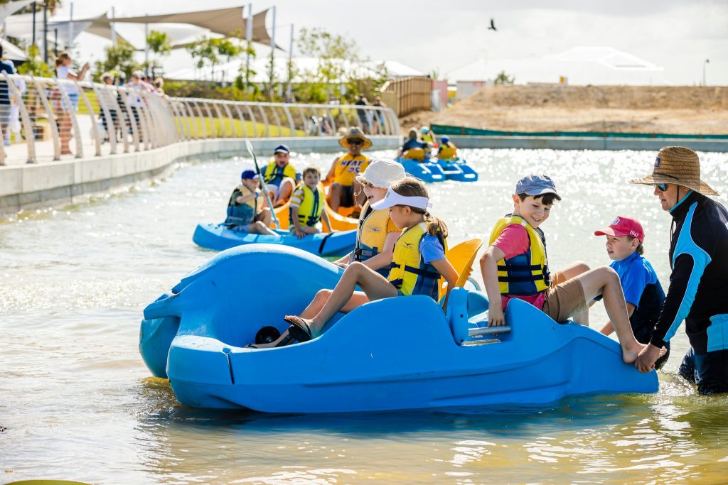
Direct water access has a social equity dimension: it works best when it isn’t limited to private backyards. Newport’s public spaces help make the water lifestyle accessible even if you don’t live on the canal.
Spinnaker Park, for example, includes a launch area for non-motorised watercraft (boards and kayaks) and a playground designed in collaboration with Touched By Olivia Foundation to support inclusive play for children of different abilities.
That sort of design has a practical social impact. It brings a wider mix of residents into the same space at similar times for similar reasons. The result is less “destination park” and more “regular meeting ground,” which is exactly what helps a community feel familiar.

Canal frontage: the backyard becomes a launchpad—and a “front fence”
Canals change household behaviour differently from a lake. A lake is a shared centre; a canal is an extension of home life.
The local council defines canals as artificial waterways connected (or intended to be connected) to tidal water, with boating access, and notes that special rates may be charged for services and activities associated with canal frontage.
Socially, canal living often shifts things in two subtle ways:
- Time becomes more weather-aware. Even if you’re not a serious boater, you tend to notice wind, rain, and water conditions more because they’re right there. That awareness often influences when you walk, paddle, or head out.
- Neighbour contact can increase. Not everyone becomes friends, but canal edges, pontoons, and visible “outdoor moments” can create more frequent acknowledgement, small interactions that can build familiarity over months.
Canal names: a community-chosen identity
Newport’s canal names were not assigned arbitrarily. In 1987, the Newport Waterways Property Owners Association (NWPOA) conducted a community poll to determine a naming theme for the canals. Residents selected Australian coastal and seabirds, a choice that has since been carried through all subsequent canal developments.
Examples include:
- Pelican Canal, running approximately 650 metres from the marina to Newport Drive and forming the backdrop to homes along Courageous Court, Griffith Road, France Court and Sverige Court.
- Jabiru Canal, extending roughly 830 metres from Albatross Canal to the Spinnaker Boulevard roundabout, behind Wildfire Court, Constance Court and Quay Circuit.
The Jabiru (also known as the black-necked stork) is Australia’s largest wetland bird, reaching about 1.4 metres in height with a wingspan exceeding two metres. While widespread, it typically occurs at low population densities — a detail reflected in the interpretive signage placed at canal ends.
Moreton Bay Regional Council formally accepted this naming tradition and installed seating and descriptive signage at the end of each canal to explain the bird species behind each name, embedding environmental storytelling into everyday movement through the suburb.
Street names: America’s Cup heritage
Newport’s street names follow a different theme, drawing from yachts that competed in the America’s Cup, particularly races held off Newport, Rhode Island, between 1930 and 1983.
One example is Valiant Court, named after Valiant (US-24), a 12-metre American challenger in the 1970 and 1974 America’s Cup campaigns. Contemporary reporting described Valiant as struggling against competitors such as Courageous, with races often decided by hull speed, positioning and wind strategy.
This dual naming approach — seabirds on the water, yachts on land — reinforces Newport’s layered identity as both a marine environment and a place shaped by sailing culture and coastal history.
A practical note buyers appreciate: canal assets have responsibilities
One of the most useful “mover insights” is that canal frontage comes with real infrastructure—some of it privately maintained.
Canal revetment walls are the responsibility of the property owner, including maintenance and ultimate replacement, and outlines that different canal types can trigger different approval pathways for works (for example, operational works in tidal canals).
This doesn’t make canal living less desirable; it just makes it clearer. The lifestyle is tied to built infrastructure, and infrastructure works best when responsibilities are understood early.
The reality check: dredging and long-term maintenance are part of the system
Living in a canal estate also means living beside a managed waterway.
Council’s Newport waterways documentation describes Newport Waterways as a residential canal estate and marina with a 2.4 km dredged entrance channel providing access to Deception Bay and the wider bay, and notes that a long-term maintenance plan has been prepared.
More practically, the council also publishes specific project information on scheduled maintenance dredging, such as the approximate volume of sediment to be removed, and the purpose is to improve navigational safety for canal users.
For movers, the key takeaway is not “expect disruption.” It’s “expect management.” Water access at this scale is a living system that’s maintained over time. It’s reassuring when you value navigable, usable waterways.
How canal maintenance actually works
Newport’s waterways operate as a managed system rather than a static feature. Council documentation describes Newport Waterways as a residential canal estate with a dredged entrance channel approximately 2.4 km long, providing navigable access to Deception Bay and the wider bay system. A long-term maintenance framework underpins this access.
Scheduled dredging
Council-managed dredging programs are carried out periodically to restore canals to their design navigational depths and to maintain safe access beneath pontoons. During the 2022 canal dredging program, residents were advised that:
- Property owners in designated dredging zones receive advance notice of schedules and sequences.
- Boats, air-docks and sea-pens may require temporary relocation to allow dredging access beneath pontoons.
- Up to five standby berths are made available at Newport Marina during dredging works.
- Vessel relocation remains the responsibility of the owner, unless authority is formally delegated to the contractor in writing.
These measures are designed to balance navigational safety with minimising disruption to daily canal use.
Revetment walls: private responsibility
Canal frontage also brings structural obligations. The concrete revetment wall separating private land from the canal beach is the sole responsibility of the landowner, not council or other authorities.
Key considerations include:
- Revetment walls are engineered to retain soil under light load conditions only.
- Additional structures built close to the wall can impose extra load, increasing the risk of cracking or wall failure.
- Damaged walls generally cannot be patched long-term; full replacement is often required and may cost $50,000 or more per panel, with repairs undertaken from the waterside using barges and heavy equipment.
Maintenance and early inspection are consistently identified as more cost-effective than reactive reconstruction after failure.
Rules matter more when the water is close
Direct access can nudge households toward boating, sometimes gradually (a paddleboard becomes a kayak; a kayak becomes a tinny), sometimes immediately. When that happens, “knowing the rules” becomes part of keeping the shared environment safe and enjoyable.
Maritime Safety Queensland states that you must hold a marine licence to operate a boat with an engine power greater than 4.5 kW and outlines the licensing types and requirements.
It also explains that speed limits apply across Queensland boating areas, with penalties for exceeding them, and notes that conditions may require travelling well below the posted maximum for safety.
This is relevant to “social impact” because shared waterways are a shared experience. Appropriate speeds and considerate wake behaviour influence how comfortable canals feel for paddlers, kids, and people using foreshore paths.
Why this matters socially
From a lifestyle perspective, infrastructure awareness reinforces Newport’s shared-system dynamic. Water access works because responsibilities are distributed clearly. When dredging schedules, wall maintenance and navigation upgrades are understood upfront, the canals remain usable, safe and predictable — qualities that support both daily routines and long-term confidence in the suburb.
The wider bay environment: zoning is part of water life
Water access in Newport can also mean access to a larger protected bay, which comes with zoning and designated-area rules.
The Moreton Bay Marine Park “entry and use provisions” tables provide practical guidance, including reminders that fishing activities must comply with fisheries restrictions and that fishing equipment must be stowed and secured when in zones where its use isn’t authorised. The current zoning plan itself is published legislation: Marine Parks (Moreton Bay) Zoning Plan 2019.
For everyday use, the Queensland parks site also promotes the Marine Parks Southern Queensland App as a way to access and understand zoning and designated area rules.
Parks shape the daily rhythm as much as the water does
Newport Park is listed by Council with practical features like a dog off-leash area, electric barbecues, play equipment, seating/shelter, toilets, and a water fountain. These are the kinds of amenities that support lingering rather than just passing through.

These places form the heart of suburb life where kids play, dogs socialise, and neighbours start recognising each other. In a waterside community, the lifestyle is shared, so it doesn’t belong only to those with a private view.
Newport’s social impact isn’t a single headline. It’s the way water access changes your defaults—how often you step outside, where you spend unplanned time, and how your neighbourhood starts to feel familiar through repetition.

Featured Image Credit: Newport Waterside/Facebook