
Laceys Creek and the Growing Appeal of Hinterland Living
At a time when much of Moreton Bay continues to urbanise, Laceys Creek remains one of the region’s most geographically defined residential pockets — modest in population, expansive in landholding and anchored to protected forest.
Located about 50 kilometres north-west of Brisbane’s CBD and just beyond Dayboro, the locality sits within the upper North Pine catchment along the approach to D’Aguilar National Park, which spans more than 36,000 hectares across the D’Aguilar Range. Laceys Creek forms part of the hinterland transition zone where private rural land meets state forest and national park, a setting that has shaped its settlement pattern for more than a century.
Recent census figures indicate a population of only a few hundred residents, with dwelling numbers similarly limited. That scale contrasts with suburban growth fronts elsewhere in the City of Moreton Bay, where individual master-planned estates can introduce thousands of residents in staged releases. In Laceys Creek, development has remained dispersed rather than consolidated.
Lot configuration reflects that distinction. While suburban Moreton Bay estates typically deliver blocks between 400 and 600 square metres, properties in Laceys Creek and adjoining hinterland pockets are commonly measured in thousands of square metres or multiple hectares. Ridgeline homesites and creek-fed flats follow the contours of the land, a legacy of earlier timber extraction, grazing and agricultural subdivision rather than formal grid planning.
Geography, Planning and Long-Term Settlement Pattern
Much of the surrounding land is zoned Rural under the City of Moreton Bay planning scheme, with environmental significance, waterway and bushfire overlays shaping development outcomes. Combined with undulating terrain, seasonal creek systems and adjacency to conservation land, these factors create structural resistance to high-density change. The locality’s low-density profile is therefore reinforced by both geography and planning controls.
Laceys Creek Road continues to function as a hinterland connector between Dayboro and the forest drive network through the ranges, linking into Mount Mee and the broader D’Aguilar system. In property terms, Laceys Creek operates within a defined framework: limited population base, large-format land parcels and environmental boundaries that provide long-term settlement stability within commuting reach of Moreton Bay’s service centres.
National Park Interface and Regional Access
Laceys Creek’s adjacency to D’Aguilar National Park defines the locality’s physical boundary and access profile. The valley sits along the interface between private rural holdings and protected conservation land, forming part of the transition zone into the D’Aguilar Range.
Laceys Creek Road operates as a direct connector to the Range Road forest drive, an established route through sections of the national park linking Mount Mee, Dayboro and adjoining hinterland communities. Archival imagery from the 1970s compared with current mapping illustrates continuity rather than transformation.

Photo Credit: Moreton Bay Libraries
Today, the road remains a rural corridor framed by forest and open land, reinforcing the area’s long-standing function as both residential spine and access route.
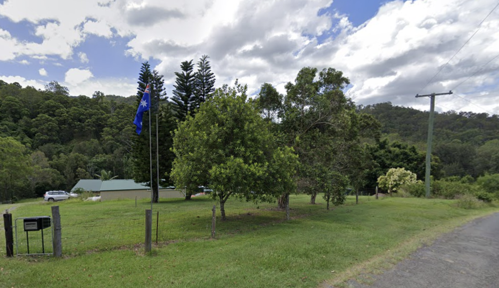
Photo Credit: Google Maps Screengrab
This proximity establishes a defined environmental buffer. Surrounding forested escarpments and conservation land limit outward expansion while anchoring the locality’s identity on the park boundary.
Recreation and Open-Space Network

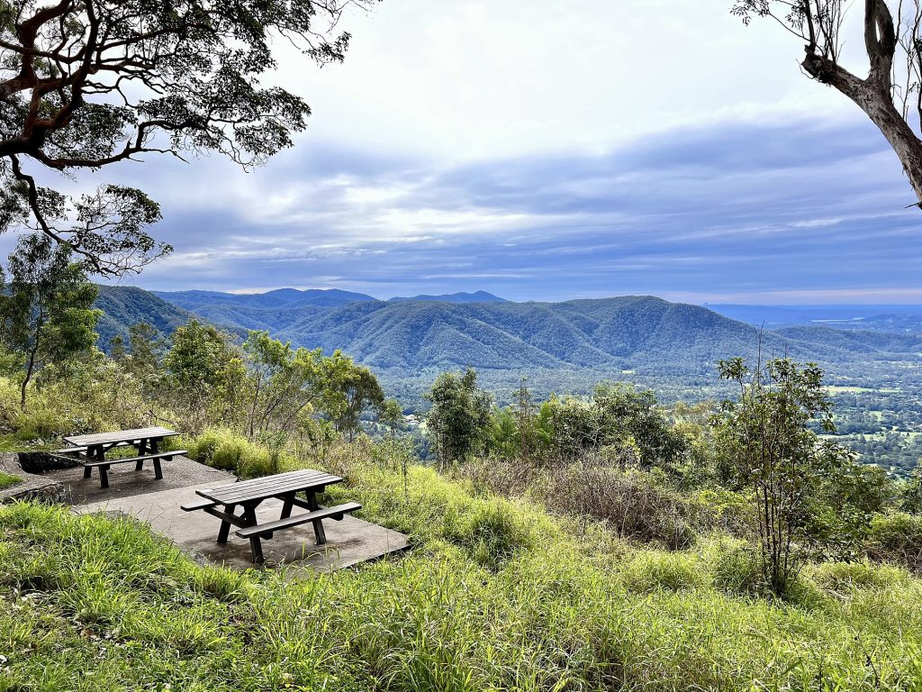
The national park interface also shapes recreation patterns. Within approximately 10 to 45 minutes’ drive, residents can access a network of local parks, forest day-use areas and regional water-based destinations.

In nearby Dayboro, Apex Park provides township green space and creekside facilities. Moving into the ranges, Rocky Hole offers creek access and short bush walks, while The Gantry combines picnic grounds, heritage timber structures and access to four-wheel-drive routes. Elevated vantage points such as Jollys Lookout remain established outlook destinations across the range system.
Collectively, these locations reinforce Laceys Creek’s position within a broader hinterland landscape. It operates as a rural residential enclave bounded by conservation land and integrated into a regional open-space network rather than suburban park provision.
Property Activity Reflecting Hinterland Demand
Acreage demand across the Laceys Creek hinterland is translating directly into price.
Between November 2025 and January 2026, the Dayboro–Mount Mee–Samsonvale–Ocean View corridor recorded consistent upper-tier activity, with multiple transactions reinforcing established premium settings rather than producing isolated highs. The defining factors remain land size, elevation, outlook and proximity to the D’Aguilar ranges.
The period’s benchmark was 1 Cedar Close, King Scrub, which sold for $2,140,000 on 6 January 2026 through Carissa Hermans. Importantly, that result did not stand alone. A cluster of sales between $1.5 million and $2 million — including 120 Basin Road, Samsonvale at $1,990,000, 104 Diane Drive, Dayboro at $1,920,000 and 306 Basin Road, Samsonvale at $1,690,000 — demonstrates depth in the upper acreage bracket.
Sub-$1.5 million transactions remain firmly positioned in lifestyle territory. 43 Woods Road, Mount Mee reached $1,615,000 on 27 November 2025 through Jason Bartholomew, while 67 Roderick Street, Dayboro achieved $1,250,000 the same day through Leigh Hutton. These figures reflect buyers prioritising usable acreage, privacy buffers and environmental positioning over proximity to retail or transport nodes.
The spread of results across King Scrub, Samsonvale, Mount Mee, Dayboro, Mount Pleasant and Ocean View indicates active turnover across adjoining hinterland pockets rather than reliance on a single micro-market. In market terms, the hinterland premium is holding, with acreage scale, separation and forest adjacency continuing to underpin value.
Recent standout transactions across the corridor include:
- 100 Hawkins Road, Kobble Creek — $1,425,000, sold 19 Nov 2025
- 120 Basin Road, Samsonvale — $1,990,000, sold 21 Nov 2025
- 306 Basin Road, Samsonvale — $1,690,000, sold 26 Nov 2025
- 43 Woods Road, Mount Mee — $1,615,000, sold 27 Nov 2025
- 67 Roderick Street, Dayboro — $1,250,000, sold 27 Nov 2025
- 104 Diane Drive, Dayboro — $1,920,000, sold 09 Dec 2025
- 14 Charles Road, Mount Pleasant — $1,580,000, sold 17 Dec 2025
- 1 Cedar Close, King Scrub — $2,140,000, sold 06 Jan 2026
- 10–12 Enchelmaier Street, Dayboro — $1,155,000, sold 12 Jan 2026
- 15 Highcrest Street, Ocean View — $1,260,000, sold 30 Jan 2026
The surrounding “forest-edge” market shows active, consistent turnover at premium levels — aligning with the locality’s wider appeal as Brisbane’s national-park neighbour, where access, acreage and outlook continue to underpin value.
Weekend Rhythms and Local Movement
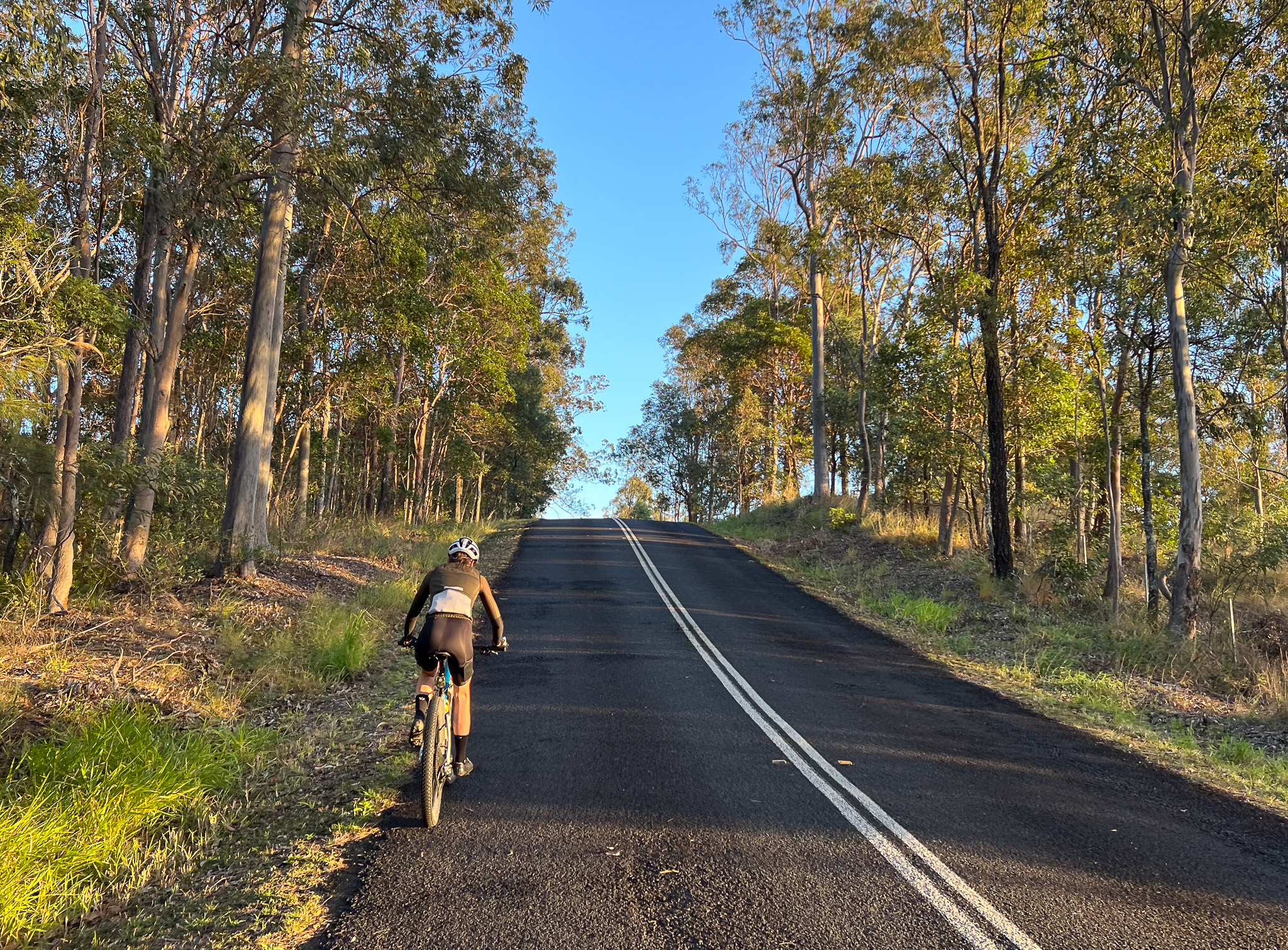
While weekdays in Laceys Creek often reflect the calm pace associated with rural living, weekends can introduce a different energy. The roads are used by cyclists, touring motorists and outdoor enthusiasts travelling between Dayboro and the D’Aguilar ranges.
Cycling routes through the Laceys Creek valley are well-known among local riders, with scenic climbs, ridgeline views and quieter country roads. The winding terrain and expansive rural vistas make it a challenging yet scenic ride, reinforcing the area’s reputation for outdoor recreation.

Dayboro can act as a service hub supporting this weekend activity, with visitors stopping for supplies, dining and fuel before or after exploring the national park network. This pattern can contribute to a distinctive balance, maintaining the tranquillity of rural living during the week while experiencing a gentle influx of visitors who value the area’s natural setting.
Practical Realities of Living Rural
Laceys Creek may not suit those who need walkable amenities, quick access to major shopping centres, or reliable “city-style” infrastructure at the doorstep. If you require short commutes, frequent public transport, or immediate access to services (medical, trades, deliveries), the distance and rural realities can feel restrictive compared to more urbanised parts of Moreton Bay.
That lifestyle comes with practical considerations that shape how people live here:
- Services and shopping: Dayboro typically serves as the closest service hub for day-to-day needs, but for larger errands, specialist services, and major retail, planning ahead and driving further afield is usually required.
- Connectivity: Internet and mobile reception can vary across hinterland pockets, influenced by terrain and property location. Many rural households factor connectivity into purchase decisions early, particularly if working from home.
- Access and travel: Winding valley roads and forest routes are part of the charm, but they also mean longer travel times than the distance on a map suggests—especially at night or in heavy weather.
- Weather and risk: Living on the edge of bushland often means being more conscious of storm impacts, fallen trees, power outages, fire preparedness, and property maintenance. Seasonal creek activity and drainage can also matter depending on the exact block position.
- Property upkeep: Acreage living can involve water storage, waste systems, fencing, pest management, and ongoing land care—a benefit for some buyers, a burden for others.
These realities don’t diminish the appeal—they’re part of the trade-off that defines the locality.
Why Laceys Creek Continues to Draw Interest
Over time, local roads have connected rural settlements, supported agriculture and linked communities across the ranges. Today, those same routes continue to shape how the locality interacts with the broader Moreton Bay region.
Laceys Creek continues to attract buyers drawn to acreage living and nature-focused lifestyles. Its appeal is clearest when it’s viewed honestly: a high-privacy, high-amenity environment with the practical demands of rural life attached. This trade-off isn’t a compromise — it’s the whole point.
